
GeoMax X-PAD - Versatile Survey Software

With an intuitive user interface and variety of field solutions to chose from, GeoMax X-PAD Survey offers advanced functionality and versatility in the field.
X-PAD Survey software is a user-friendly, comprehensive field software design to work with all GeoMax GNSS and Total Stations. Choose from a suite of field solutions to best suit your application including:
Roading
GIS & Utility Detection Collection
Auto Measuring
Scanning
Bathymetry Surveys
Surfaces & Volumes
Data Collections
Reporting
GeoMax developed X-PAD Survey after conducting extensive customer research and analysing their daily tasks, the common challenges presented and their job requirements. They identified a need for a complete field-to-office solution to offer surveyors in the field ultimate flexibility.
Key GeoMax X-PAD Survey Features:

MAPS
X-PAD allows you to use different types of maps as a basis references for the survey and stakeout activities, therefore you can see all of your data overlapped on to a map. You can choose between Google maps, Bing, Open Street, ArcGIS MAP, OViMap, TopoMap, and Topo4U.
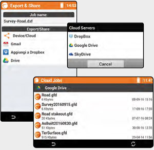
DATA Import & Exports
With X-PAD you can open and import the following formats DXF, ASCII, GSI, LandXML, ESRI Shape, SDR, IDX and 12D even if it’s in the cloud (Google Drive, Microsoft OneDrive and Dropbox) and access from the office or even the field.

X-Pole [One Pole, two Systems]
GeoMax X-Pole allows the user to work simultaneously between the TPS and GNSS by combining the advantages of both systems. The integration of X-Pole into the field software allows the user to toggle between both measurements systems.

Surface & Volumes
X-PAD can calculate terrain models from the measured points with the options to define breaklines and boundaries. The user can build as many models as you like, display it in different ways, even with the contour lines and immediately get the 2D and 3D surfaces. Within the volume calculations determine at a glance the cubic meters, add swell or shrink factor and generate your report.

Roading
The Roading module allows you to load, manage and perform alignment stakeouts of works such as roads, highways and canals. At any moment the user can see plans, vertical profiles and cross sections.
You can stake all elements of the work (axes, edges, sideslopes, walls, ditches, etc.) at any station and with any offset, using the cross-sections, the edge polylines or by defining one or more sections template that will be extruded along the alignment. With the “Where am I?” function X-PAD Survey makes it easier.

GIS Functionality
With X-Pad record all the information you want.. With the integrated GIS module this allows you to create your GIS features and to define the corresponding attributes that can be filled when the point is stored.